STAR.VISION Releases Space Computing Results of Bahrain
STAR.VISION, in collaboration with Oman Lens, released space computing results of Bahrain from 2005 to 2024, showcasing urban development and ecological changes in key areas of Bahrain.
December 16, 2024 @ STAR.VISION
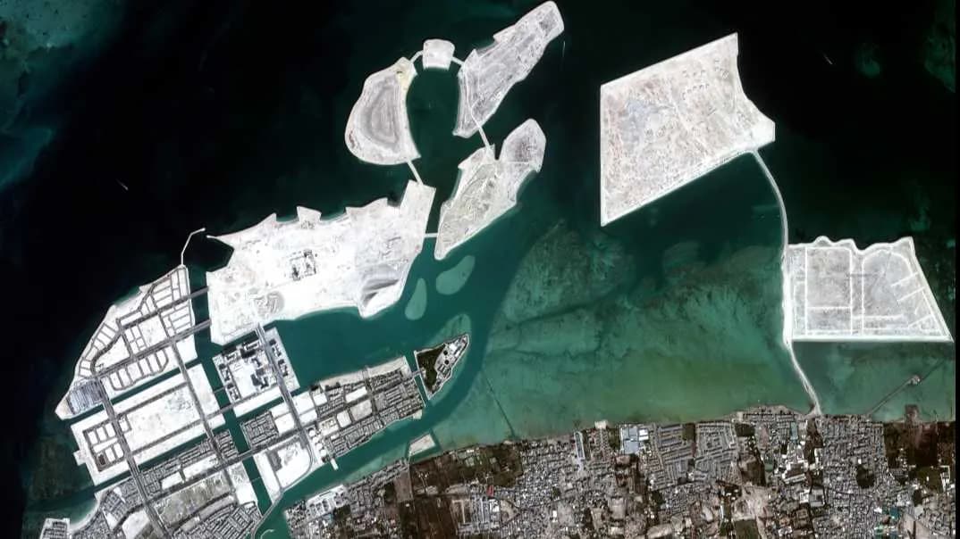
To celebrate Bahrain’s National Day on December 16 and the 25th anniversary of King Hamad bin Isa Al Khalifa’s ascension to the throne, STAR.VISION, in partnership with Oman Lens and the Bahrain National Space Science Agency (NSSA), jointly developed and presented the satellite space calculation results from 2005 to 2024. The results comprehensively document the development of key areas, including Diyar Al Muharraq and the Amwaj Islands.
Advanced AI Analysis Technology
In this collaboration, STAR.VISION leveraged its technical advantages in high-definition satellite image acquisition and advanced remote sensing AI algorithms. By intelligently processing a massive volume of data from the past 20 years, we quickly extracted details of urban development, transportation networks, land use, and environmental changes. These analyses not only reveal milestone achievements in urban planning, infrastructure construction, and social development in Muharraq Province but also provide valuable references for scientific decision-making and future development.
Using AI algorithms, we can conduct dynamic monitoring and trend analysis of large-scale infrastructure and environmental changes in a short period. For example, by comparing satellite images from different years, we can quickly identify new buildings, changes in coastlines, and green space distribution, generating visual reports that directly support government and relevant agencies in planning and project monitoring.


Looking to the Future
STAR.VISION plans to expand the application of its satellite high-definition imagery and AI technology to various fields, including urban development, ecological protection, agriculture and forestry, and resource management. For instance:
• Urban Planning: Helping optimize transportation network design and monitor the impact of urban expansion on the environment.
• Ecological Protection: Real-time tracking of changes in wetlands, mangroves, and desert ecosystems, providing evidence for environmental protection policies.
• Agriculture and Forestry: Using remote sensing analysis to accurately measure cultivated land area, crop growth, and forest coverage changes, promoting agricultural productivity and sustainable development.
• Disaster Management: Providing real-time monitoring data for natural disasters such as floods and sandstorms, enhancing emergency response capabilities.
STAR.VISION, Oman Lens, and the Bahrain National Space Science Agency will further deepen their cooperation, fully enhancing satellite technology capabilities and contributing to recording and witnessing Bahrain’s development.


Stay Informed
Subscribe STAR.VISION’s Newsletter
If you would like to receive email updates from STAR.VISION Newsroom, please complete the information above.